
Disaster and Disaster Management
Examine the primary causes of the rising landslide frequency in India and critically analyze the present landslide disaster management framework.
The movement of a mass of rock, rubble, or dirt down a slope is called a landslide. They belong to the category of mass wasting, which includes any rock and soil movement that occurs downhill due to gravity alone. They usually grow on soil that is rich in clay.
Sections of India at Risk of Landslides
The Landslide Atlas of India was recently released by the ISRO. According to this atlas, the following are some notable figures about landslides in India:
- One of the top five landslide-prone nations in the world is India.
With the exception of regions covered in snow, landslides can occur in about 12.6% of India’s total land area.
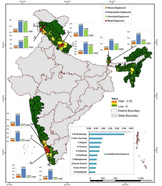
The following is a rough breakdown of landslides that have been reported in India:
- From the North-Western Himalayas, roughly 66.5 percent
- From the Himalayas in the northeast, roughly 18.8% come
- From the Western Ghats, approximately 14.7%.
As per the Landslide Atlas of India, major landslide prone areas in India are as follows:
- The Northeastern Region (comprises about 50 percent of the total landslide prone areas in India)
- Areas of Uttarakhand, Himachal Pradesh, and Jammu & Kashmir lying along the Himalayas.
- Areas of Maharashtra, Goa, Karnataka, Kerala, and Tamil Nadu lying along the Western Ghats.
- The Araku region in Andhra Pradesh along the Eastern Ghats.
Government Initiatives to deal with landslides:
In India, some notable actions implemented to effectively manage landslides include the following:
- The 2005 Disaster Management Act offers a thorough institutional and legal framework for managing several types of catastrophes, including landslides.
- All facets of landslide catastrophe risk reduction and management, including hazard mapping, monitoring, and early warning systems, are covered by the National Landslide Risk Management Strategy (2019).
- The actions that should be done to lower the danger of landslides are outlined in the Guidelines on Landslide Hazard Management, published by the National Disaster Management Authority (NDMA) in 2009.
- Various national and state-level disaster management authorities have been receiving assistance from the National Institute of Disaster Management (NIDM) in the form of capacity building and other support.
- An attempt has been made to improve weather forecasting. For instance, Ensemble Prediction System. This will aid in the prediction of landslide disasters.
- The National Landslide Susceptibility Mapping (NLSM) project aims to map out the nation’s landslide-prone regions.
- In India, the Central Water Commission (CWC) and the Geological Survey of India (GSI) are also active in landslide management.
Implementing National Landslide Risk Management Strategy by NDMA:
Landslide Hazard Zonation:
- The plan places a strong emphasis on the necessity of confirming and bolstering landslide zoning maps.
- It suggests making use of cutting-edge equipment like high-resolution Earth observation data, terrestrial laser scanners, and unmanned aerial vehicles (UAVs).
- The publication recommends developing macro (1:50,000 / 25,000) and meso (1:10,000) maps, as well as putting monitoring and quality-checking procedures in place.
Monitoring and Early Warning System for Landslides:
- The publication summarizes prior research, points out gaps, and makes recommendations for the future.
- These ideas include the creation of rainfall thresholds, automatic rain gauges, wireless sensor networks (WSN), numerical weather prediction (NWP), and micro-electro-mechanical sensors (MEMS).
Awareness Programs:
- The approach emphasizes how crucial it is to involve the community in increasing awareness and preparing for emergencies.
- The goal is to support communities in being proactive and having efficient emergency response plans.
Capacity Building and Training:
- The study suggests implementing new technology for training programs and capacity building, as well as a national Training Need Assessment (TNA) in Landslide Risk Management.
- It highlights the necessity of fortifying the response framework at the local level.
Regulations and Policies for the Mountain Zone:
- According to the plan, land-use policies and a techno-legal regime will be established. Additionally, building codes will be updated and enforced, BIS codes and landslide management guidelines will be reviewed and revised, and town and country planning laws will be modified for places vulnerable to natural hazards.
Landslide Stabilization and Mitigation:
- The document outlines the necessity of implementing particular land-use plans, enforcing building codes, and proposing changes to local and national planning laws in places that are vulnerable to landslides.
Establishment of a Special Purpose Vehicle (SPV) for Landslide Management:
- The strategy highlights the work done by the Task Force, which includes the proposed establishment of a “Centre for Landslide Research Studies and Management,” low-cost landslide monitoring solutions, training and capacity building programs, and pilot projects for landslide hazard zonation maps.
One of the most common natural disasters in India is landslides, which can have a significant impact. A proactive strategy to landslide prevention and mitigation becomes essential as societies continue to develop into susceptible areas.