
1. Ol Chiki script, recently seen in news, is associated with which one of the following languages?
(a) Bodo
(b) Dhongri
(c) Maithili
(d) Santhali
Answer: (d) Santhali
Explanation:
In NEWS: Ol Chiki Script – 100 Years of Linguistic Empowerment
Ol Chiki Script:
- Ol Chiki is a script developed specifically for the Santhali language. Hence option (d) is correct.
- It was created in 1925 by Pandit Raghunath Murmu.
- Santhali belongs to the Austroasiatic language family.
- Ol Chiki consists of 30 letters designed to represent Santhali phonetics accurately.
- Each symbol corresponds directly to a distinct sound, making it a phonetic script.
- The script was developed to overcome limitations of borrowed scripts like:
- Roman
- Bengali
- Odia
- Devanagari.
- The creation of Ol Chiki enabled Santhali to transition from an oral tradition to a structured written language.
- Santhali language was included in the Eighth Schedule of the Constitution of India in 2003 through the 92nd Constitutional Amendment Act.
- Ol Chiki is widely used in regions where Santhali speakers are concentrated:
- Jharkhand
- Odisha
- West Bengal
- Assam
- Bihar.
- The Constitution of India has been translated into Santhali using the Ol Chiki script (released in 2025).
- The Government of India released a ₹100 commemorative coin and postage stamp to mark the centenary of the Ol Chiki script.
| PYQ REFERENCE: (2024) Q. The Constitution (71st Amendment) Act, 1992 amends the Eighth Schedule to the Constitution to include which of the following languages? 1. Konkani 2. Manipuri 3. Nepali 4. Maithilis Select the correct answer using the code given below: (a) 1, 2 and 3 (b) 1, 2 and 4 (c) 1,3 and 4 (d) 2.3 and 4 |
Source: https://www.pib.gov.in/PressReleasePage.aspx?PRID=2228697®=3&lang=1
2. During a break in the southwest monsoon, which of the following changes are most likely?
1. Suppressed convection over peninsular and central regions.
2. Enhanced rainfall along the foothills of Himalayas.
3. Strengthening of low-pressure systems over central India.
Select the correct answer using the code given below:
(a) 1 and 2 only
(b) 2 and 3 only
(c) 1 only
(d) 1, 2 and 3
Answer: (a) 1 and 2 only
Explanation:
In NEWS: Desert winds during monsoon breaks can be used for early warnings: Study
Monsoon Breaks in India (Break Monsoon):
- A monsoon break refers to a temporary weakening or pause in rainfall during the Southwest Monsoon season (June–September).
- During break conditions:
- Rainfall reduces significantly over central India and Indo-Gangetic plains.
- Rainfall often increases over Himalayan foothills and northeast India, sometimes causing floods.
- Breaks occur when the monsoon trough shifts northwards towards the Himalayan region.
- The monsoon trough is a low-pressure zone extending from northwest India to the Bay of Bengal, controlling monsoon rainfall distribution.
- Active and break phases are part of the intraseasonal variability of the monsoon.
Meteorological Characteristics
- Weakening of low-pressure systems over central India. Hence statement 3 is incorrect.
- Reduced moisture transport from the Arabian Sea.
- Suppressed convection over peninsular and central regions. Hence statement 1 is correct.
- Enhanced rainfall along Himalayan foothills due to orographic uplift. Hence statement 2 is correct.
Causes / Drivers
- Northward shift of the monsoon trough.
- Madden–Julian Oscillation (MJO) phases.
- Interaction with western disturbances.
- Variability in sea surface temperatures and monsoon circulation.
- Role of Desert Winds (New Study Findings)
- Dry winds (dry intrusions) originating from west and northwest of India trigger monsoon breaks.
- These winds originate from dry regions west of the Hindu Kush (near Afghanistan–Iran–Turkmenistan region).
Impacts
- Temporary dry spells affecting agriculture and sowing cycles.
- Increased risk of floods and landslides in Himalayan regions.
- Alters seasonal rainfall distribution even if total monsoon rainfall remains near normal.
| PYQ REFERENCE: (1996) Q. High temperature and low pressure over the Indian subcontinent during the summer season draws air from the Indian Ocean leading to the in-blowing of the: (a) South-east monsoon (b) South-west monsoon (c) Trade winds (d) Westerlies |
3. Which one of the following best describes the objective of the PM RAHAT Scheme, recently seen in the news?
(a) To provide financial compensation for damaged vehicles in road accidents
(b) To ensure cashless hospitalization and assured treatment for road accident victims
(c) To promote expansion of national highways across border areas
(d) To regulate motor vehicle insurance claims settlement
Answer: (b) To ensure cashless hospitalization and assured treatment for road accident victims
Explanation:
In NEWS: Government Launches “PM RAHAT” – Cashless Treatment of Road Accident Victims
PM RAHAT Scheme:
- PM RAHAT (Road Accident Victim Hospitalization and Assured Treatment) is a Central Government initiative aimed at providing cashless treatment to road accident victims. Hence option (b) is correct.
- The scheme focuses on reducing preventable deaths by ensuring treatment within the Golden Hour after accidents.
- It provides cashless medical treatment up to ₹1.5 lakh per victim.
- Coverage is available for a period of 7 days from the date of accident.
- Stabilization treatment provisions:
- Up to 24 hours for non-life-threatening cases.
- Up to 48 hours for life-threatening cases (subject to police authentication).
- Applicable to accident victims on any category of road (national, state, or local roads).
- Integrated with Emergency Response Support System (ERSS) – 112 helpline for quick emergency response.
- Accident victims or Good Samaritans (“Rah-Veer”) can call 112 to locate designated hospitals and ambulance services.
- Implemented using technology platforms:
- Electronic Detailed Accident Report (eDAR) system of Ministry of Road Transport & Highways.
- Transaction Management System (TMS 2.0) of National Health Authority.
- Digital workflow includes accident reporting, police verification, hospital admission, claim processing and payment.
- Financial reimbursement made through the Motor Vehicle Accident Fund (MVAF).
- Funding sources:
- Contributions from general insurance companies (for insured vehicles).
- Government budget allocation (for uninsured and hit-and-run cases).
- Claims approved by State Health Agencies to be settled within 10 days.
- District-level grievance redressal handled by officer nominated by District Road Safety Committee.
- Objective: strengthen emergency care ecosystem and ensure no accident victim is denied treatment due to lack of money.
Source: https://www.pib.gov.in/PressReleasePage.aspx?PRID=2228172®=3&lang=1
4. With reference to the Panchsheel principles, consider the following:
1. Mutual respect for each other’s territorial integrity and sovereignty
2. Mutual non-aggression
3. Mutual non-interference in internal affairs
4. Equality and mutual benefit
5. Peaceful coexistence
Which of the above constitute the principles of Panchsheel?
(a) 1, 2 and 3 only
(b) 2, 3 and 5 only
(c) 1, 4 and 5 only
(d) 1, 2, 3, 4 and 5
Answer: (d) 1, 2, 3, 4 and 5
Explanation:
In NEWS:
Panchsheel Agreement:
- The Panchsheel Agreement was signed in 1954 between India and China.
- Officially known as the Agreement on Trade and Intercourse between the Tibet Region of China and India.
- Signed during the tenure of Prime Minister Jawaharlal Nehru.
- Based on the doctrine of Panchsheel (Five Principles of Peaceful Coexistence).
Five Principles of Panchsheel:
1. Mutual respect for each other’s territorial integrity and sovereignty.
2. Mutual non-aggression.
3. Mutual non-interference in internal affairs.
4. Equality and mutual benefit.
5. Peaceful coexistence. Hence all are correct.
Key Features:
- Recognised Tibet as a region of China and regulated trade relations.
- Aimed to promote peaceful India-China relations after independence.
- Reflected India’s early foreign policy based on non-alignment and peaceful coexistence.
- Panchsheel principles later influenced international diplomacy and NAM ideology.
| PYQ REFERENCE: (2011) Q. With reference to the “Look East Policy” of India , consider the following statements? 1. India wants to establish itself as an important regional player in East Asian affairs. 2. India wants to plug the vacuum created by the termination of the Cold War. 3. India wants to restore the historical and cultural ties with its neighbours in Southeast and East Asia. Which of the statements given above is/are correct? (a) 1 only (b) 1 and 3 only (c) 3 only (d) 1, 2 and 3 |
5. Which of the following rivers is associated with the landscape of Rajaji National Park?
1. Ganga River
2. Chilla River
3. Suswa River
Select the correct answer using the code below:
(a) 1 only
(b) 1 and 2 only
(c) 1, 2 and 3
(d) 2 and 3 only
Answer: (c) 1, 2 and 3
Explanation:
In NEWS: SC clears metalling of road through Rajaji National Park
Background of the Case
- The Supreme Court allowed construction of the Laldhang–Chillarkhal road connecting Kotdwar and Haridwar.
- Total length: 11 km, with 4.7 km passing through Rajaji National Park.
- The project had been under stay since January 11, 2023.
About Rajaji National Park:
- Rajaji National Park is located in the state of Uttarakhand.
- The park lies along the Shivalik (Siwalik) ranges in the Himalayan foothills.
- Rajaji National Park was formed in 1983 by merging:
- Rajaji Wildlife Sanctuary
- Motichur Wildlife Sanctuary
- Chilla Wildlife Sanctuary.
- The park is named after C. Rajagopalachari (Rajaji), freedom fighter and India’s first Governor-General.
- The total area of Rajaji National Park is approximately 820.42 sq km.
- The park extends across districts including: Pauri Garhwal, Dehradun (Earlier reference includes Saharanpur region area).
- Motichur and Rajaji sanctuaries are contiguous, while Chilla sanctuary is separated by the Ganga River and Chilla River. Hence 1 and 2 are correct.
- The park lies in a transition zone between the Western Himalaya and Central Himalaya, enhancing biodiversity.
- Rajaji landscape includes:
- Hills and foothills
- Riverine areas
- Terai grasslands
- Mixed deciduous forests.
- Dominant vegetation includes Sal forests.
- Forest types range from: Semi-evergreen, Deciduous, Mixed broad-leaved forests, Terai grasslands.
- The vegetation is classified under Indus-Ganges Monsoon Forest type.
- Several seasonal streams descend from the Siwalik ridge; they remain dry but become torrential during monsoon.
- The Suswa River forms the northern boundary of parts of the park. Hence 3 is correct.
- Rajaji National Park is rich in avifauna, with about 400 bird species recorded.
- Notable bird species include:
- Great Hornbill
- Black-necked Stork
- Pallas’s Fish Eagle
- Northern Goshawk
- Yellow-billed Blue Magpie.
- The park is known for both forest foothill birds and open grassland species.
- Major birding areas include:
- Forest rest houses
- Chilla forest drive (approx. 26 km)
- Phanduwala–Kansrao–Motichur trail (~40 km).
| PYQ REFERENCE: (2020) Q. Which of the following Protected Areas are located in the Cauvery basin? 1. Nagarhole National Park 2. Papikonda National Park 3. Sathyamangalam Tiger Reserve 4. Wayanad Wildlife Sanctuary Select the correct answer using the code given below: (a) 1 and 2 only (b) 3 and 4 only (c) 1, 3 and 4 only (d) 1, 2, 3 and 4 |
Source:
https://rajajinationalpark.co.in/1.about.htm
6. Consider the following statements:
1. It is an urban freshwater lake situated in the Kashmir Valley.
2. It is often called the “Jewel in the crown of Kashmir” due to its scenic and cultural importance.
3. It has floating gardens locally known as “Raad”, used for vegetable cultivation.
Which one of the following lakes is best described in the statements given above?
(a) Wular Lake
(b) Dal Lake
(c) Pangong Tso
(d) Tso Moriri
Answer: (b) Dal Lake
Explanation:
In NEWS: Why has J&K shelved the Dal Lake restoration plan?
Dal Lake:
- Dal Lake is located in Srinagar, Jammu & Kashmir.
- It is an urban freshwater lake situated in the Kashmir Valley.
- Often called the “Jewel in the crown of Kashmir” due to scenic and cultural importance.
- It has floating gardens locally known as “Raad”, used for vegetable cultivation. Hence option (b) is correct.
- The lake is connected to other water bodies through channels and wetlands in the Jhelum basin.
- Dal Lake contains multiple basins including:
- Gagribal
- Lokut Dal
- Bod Dal
- Nagin (sometimes treated as separate but hydrologically linked).
- Known for houseboats and shikara transport, forming a unique human–lake interaction ecosystem.
- Important for tourism, fisheries, agriculture and local livelihoods.
- Classified as a significant urban wetland ecosystem in India.
- Major environmental issues:
- Eutrophication (nutrient enrichment)
- Encroachment and shrinking area
- Sewage inflow and pollution
- Excess aquatic weed growth
- Siltation from catchment erosion.
- Conservation initiatives involve:
- De-weeding operations
- Sewage treatment measures
- Regulation of houseboats
- Catchment area management.
- Dal Lake is part of Himalayan lacustrine systems influenced by glacial and fluvial processes.
| PYQ REFERENCE: (2018) Q. Which one of the following is an artificial lake? (a) Kodaikanal (Tamil Nadu) (b) Kolleru (Andhra Pradesh) (c) Nainital (Uttarakhand) (d) Renuka (Himachal Pradesh) |
7. With reference to recent discoveries, the term “Cikai Korran” refers to which one of the following?
(a) A personal name identified in Tamil-Brahmi inscriptions discovered in Egyptian tombs.
(b) A Chera ruler mentioned in Sangam literature
(c) A Buddhist monk associated with Southeast Asian trade routes
(d) A Roman official referred to in Indian epigraphic records
Answer: (a) A personal name identified in Tamil-Brahmi inscriptions discovered in Egyptian tombs.
Explanation:
In NEWS: How Tamil, Sanskrit and Prakrit names ended up on the walls of Egyptian Pharaohs’ tombs
About “Cikai Korran”:
- “Cikai Korran” is a personal name identified in Tamil-Brahmi inscriptions discovered in Egyptian tombs. Hence option (a) is correct.
- The name appears multiple times (about eight inscriptions) across several tombs in Egypt’s Valley of the Kings.
- It is written in Tamil-Brahmi script, indicating early Tamil literacy.
- The inscriptions are dated roughly between the 1st and 3rd centuries CE.
- The name reflects linguistic hybridity:
- “Cikai” possibly linked to Sanskrit word śikhā (meaning tuft or crown).
- “Korran” is distinctly Tamil, associated with victory or warrior identity.
- The Tamil component relates to:
- Koṟṟavai — a warrior goddess in Tamil tradition.
- The term koṟṟavaṉ meaning king or victorious person.
- The repeated carving suggests deliberate marking of presence by an Indian traveller or merchant.
- The inscriptions indicate that Indian visitors travelled inland in Egypt, not just coastal trade centres.
- Similar Tamil names appear in Sangam-age literature and inscriptions, linking the find to early historic Tamilakam.
- The name demonstrates the cosmopolitan and multilingual nature of ancient Indian trading communities.
- It strengthens evidence of Indo-Mediterranean cultural interactions during the Roman trade period.
| PYQ REFERENCE: (2020) Q. With reference to the cultural history of India, which one of the following is the correct description of the term ‘paramitas’? (a) The earliest Dharmashastra texts written in aphoristic (sutra) style (b) Philosophical schools that did not accept the authority of Vedas (c) Perfections whose attainment led to the Bodhisattva path (d) Powerful merchant guilds of early medieval South India |
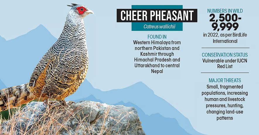
8. With reference to the Cheer Pheasant, consider the following statements:
1. It inhabits grassland and scrub ecosystems of the western Himalayas.
2. It is classified as “Endangered” under the IUCN Red List.
3. It is a ground-dwelling bird whose nesting is vulnerable to wildfires.
4. It is included in Schedule I of the Wildlife (Protection) Act, 1972.
Which of the statements given above are correct?
(a) 1 and 3 only
(b) 1, 3 and 4 only
(c) 2 and 4 only
(d) 1, 2, 3 and 4
Answer: (b) 1, 3 and 4 only
Explanation:
In NEWS: On a slippery slope – Hunting and habitat degradation remain the biggest threats of this ground-dwelling bird
The cheer pheasant:
- The cheer pheasant (Catreus wallichii) derives its name from its loud “chir-a-pir” call, common across western Himalayan valleys. Hence statement 1 is correct.
- It is classified as Vulnerable (IUCN Red List) due to small and fragmented populations. Hence statement 2 is incorrect.
- The species occurs across the western Himalayas — from northern Pakistan, Kashmir, Himachal Pradesh, Uttarakhand to central Nepal.
- It inhabits steep rocky slopes, grasslands, scrub vegetation at elevations of about 1,200–3,350 metres.
- The bird is ground-dwelling, with nests built as simple ground scrapes under vegetation or rocks. Hence statement 3 is correct.
- It shows high natal philopatry, meaning individuals often breed near their birthplace.
- The species depends on early successional grasslands, historically maintained by traditional grass cutting and controlled burning.
- Major threats include habitat loss, agricultural expansion, afforestation, human and livestock pressure, hunting, and land-use change.
- Wildfires during breeding season (April–June) destroy nests and chicks, affecting population recruitment.
- Conversion of grasslands into dense forests or agricultural terraces reduces suitable habitat.
- The species receives the highest protection under Schedule I of the Wildlife (Protection) Act, 1972. Hence statement 4 is correct.
- It is also listed in Appendix I of CITES, regulating international trade.
- Conservation measures include demographic studies, connectivity research, anti-hunting enforcement, community participation, and a coordinated range-wide conservation action plan.
Source: https://www.downtoearth.org.in/wildlife-biodiversity/on-a-slippery-slope
9. Exercise MILAN is primarily associated with which one of the following objectives?
(a) Nuclear deterrence cooperation among Indo-Pacific nations
(b) Anti-piracy operations in the Gulf of Aden only
(c) Exclusive bilateral naval exercises between India and ASEAN countries
(d) Multilateral maritime security cooperation and naval interoperability
Answer: (d) Multilateral maritime security cooperation and naval interoperability
Explanation:
In NEWS: INDIAN NAVY INAUGURATES MILAN VILLAGE AS PART OF EXERCISE MILAN 2026, VISAKHAPATNAM
Exercise MILAN 2026:
- Exercise MILAN is a flagship multilateral naval exercise conducted by the Indian Navy.
- MILAN 2026 is being held at Visakhapatnam under the Eastern Naval Command.
- The exercise aims to enhance:
- Interoperability among participating navies
- Maritime domain awareness
- Collective response capabilities. Hence option (d) is correct.
- Navies from over 70 countries are participating, making it one of the largest multilateral naval exercises in the Indo-Pacific.
- The exercise includes:
- Harbour Phase (professional interactions, seminars, cultural exchanges)
- Sea Phase (operational exercises)
Operational Focus Areas
- Anti-submarine warfare (ASW)
- Air defence operations
- Search and rescue missions (SAR)
- Cooperative maritime security operations
Source: https://www.pib.gov.in/PressReleasePage.aspx?PRID=2228574®=3&lang=1
10. Consider the following information:
| S.no | Archaeological Site | State | Description |
| 1. | Chandraketugarh | Odisha | Trading Port town |
| 2. | Inamgaon | Maharashtra | Chalcolithic site |
| 3. | Mangadu | Kerala | Megalithic site |
| 4. | Salihundam | Andhra Pradesh | Rock-cut shrines |
In which of the above rows is the given information correctly matched ?
(a) 1 and 2
(b) 2 and 3
(c) 3 and 4
(d) 1 and 4
Answer: (b) 2 and 3
Explanation:
- Chandraketugarh is located in West Bengal, not Odisha (though it was an important ancient trading centre). Hence pair 1 is incorrect.
- Inamgaon is a well-known Chalcolithic (Jorwe culture) archaeological site in Maharashtra. Hence pair 2 is correct.
- Mangadu is associated with Megalithic cultural remains in Kerala. Hence pair 3 is correct.
- Salihundam is primarily a Buddhist site with stupas, chaityas and monasteries, not known for rock-cut shrines. Hence pair 4 is incorrect.